
Navigating a Fragmented Landscape
As humans, we take for granted how easily we can travel across our landscape. We’ve explored every continent, the depths of our oceans, and even made it past our atmosphere. We do this by connecting these seemingly isolated areas through means of transportation and landscape connectivity.
But what if you were a bear, bee, or flower? How do you get from one place to the next in search of food, mates, and proper shelter? How have humans made such tasks more difficult, further risking the very existence of our wildlife?
When we alter the landscape by building roads and other structures, we essentially break up natural areas into separate patches. This reduces the total area of available habitat, making it increasingly difficult for plants and animals to get around. It’s what’s referred to as habitat loss and fragmentation. It’s also one of THE leading causes of species extinction.
What About Climate Change?
Climate change is another problem dwindling populations have to face. With increasing temperatures, more frequent storms, draughts and desertification, habitats are being altered at alarming rates.
For some species, this will actually have a positive impact on their survival. It does so by expanding their range (i.e. the geographic area that provides suitable habitat conditions). For example, the spread of disease-bearing ticks into more northern latitudes. Many species however are not so lucky. Rather, they have to deal with shrinking or shifting ranges.
This makes the issue of habitat fragmentation and landscape connectivity even more crucial. It’s also further complicated by the need to consider both the present day and future implications of development.
Thankfully, we have technology to the rescue! With present-day modelling, we can now predict how these changes will impact a landscape. We can even go so far as to predict where species will migrate to seek refuge. Combining climate science with conservation makes for much more resilient planning!💪
The Game Changer: Satellite Imagery
When most people picture conservationists they probably think of someone in a safari hat in the middle of a dense forest, surrounded by bugs and hugging trees or something. For the most part, this is pretty accurate. However! Much of our work is now being done behind a computer with the help of high-resolution satellite imagery.
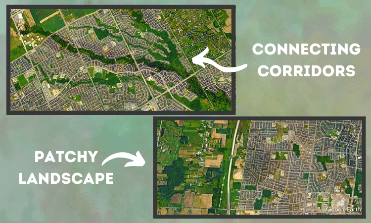
As the quality of these images (taken from space🤯) continues to improve, we can analyze our landscape like never before. The images are great at helping us track urban sprawl. In addition, they assist with the identification of problematic areas for wildlife, distinguishing isolated patches of green or blue.
One of the best advantages of this tool is that, for the most part, it’s absolutely free. The above images are retrieved using Google Earth. It’s available for anyone to download or use online. Just by quickly searching around my own neighbourhood, I was able to find examples of bad and good landscape connectivity. Why not try it for yourself?
By looking at the landscape this way, we have gained significant insight into where we need to connect it.
Why Did the Chicken Cross the Road? More like how?!
The most obvious way we section off habitats and land types is by building roads. This is a major obstruction for animals trying to move from one patch to another. In fact, vehicle collisions cause millions of wildlife deaths each year.
Where I live in southern Ontario, one of our leading conservation efforts is turtle rehabilitation. It is not surprising that these leisurely reptiles find it difficult to cross roads unscathed. This is one of the main reasons 7-8 out of our 9 turtles are now listed as “Species at Risk.”🐢.
Until recently, our best management plan was posting animal crossing signs. I know… It’s really no surprise that we have such high fatality rates.
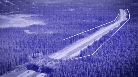
But what if critters had a way to get over, or under these carnage highways? We are beginning to build more wildlife bridges and tunnels to provide animals safe passage. Implementing solutions like these can eliminate up to 95% of animal collisions.
Creating Green Pathways
Bridges and tunnels are great when we look at situations where roads divide a relatively natural landscape. What about areas that are more grey than green?
Within an urban environment, wildlife is limited to small parks. Oftentimes these do not provide the best quality habitats for sustaining stable populations. So plants and animals rely on a network of greenspaces. This makes it easier to access basic resources and establish sufficient genetic variability for their survival.
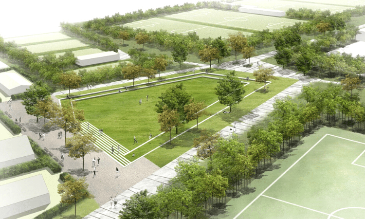
Urban planners are beginning to implement projects that recognize the essential role these spaces play in cities. Toronto has their own project called “The Meadoway.” It aims to restore a 16 km strip of hydro corridor as a pollinator habitat. It also integrates important community-based initiatives making it a systemic approach to conservation planning.
Another way we are creating pathways is by investing in living infrastructure. Things like green roofs and walls provide food and shelter for pollinators and birds as they navigate through our cities. We can even help out by creating our own natural refuges in our backyards and on our balconies.
We Are All Connected
As governments set targets for land and ocean conservation, it’s no longer enough to say how much we need to conserve, but where. We need to identify where habitats are under threat and how we can connect it to better support thriving populations across our landscapes.
We need to ensure species can safely travel from patch to patch, especially as we face more trying times ahead.
Luckily we have a growing number of solutions to address these issues and every one of us can play a role. In addition to providing wildlife habitat on our own properties, we can stand up against development plans that pave over important natural spaces.
Unlike the plants and animals we share the planet with, our voices have the power to sway decision makers. It’s up to us to ensure effective conservation is at the forefront of future planning.

Leave a comment